
Our Pacific Paradise
Half way between Noumea and Auckland, the former penal settlement of Norfolk Island is a paradise of mountain peaks and sea cliffs
The cluster of small islands known as the Territory of Norfolk Island lies in the south-western Pacific Ocean, 1400km due east of Evans Head, NSW, about half way between New Caledonia and New Zealand. Comprising Norfolk Island (proper) and two small, uninhabited islands, Phillip and Nepean, to its south, the group is administered by the Australian Government as an external territory.
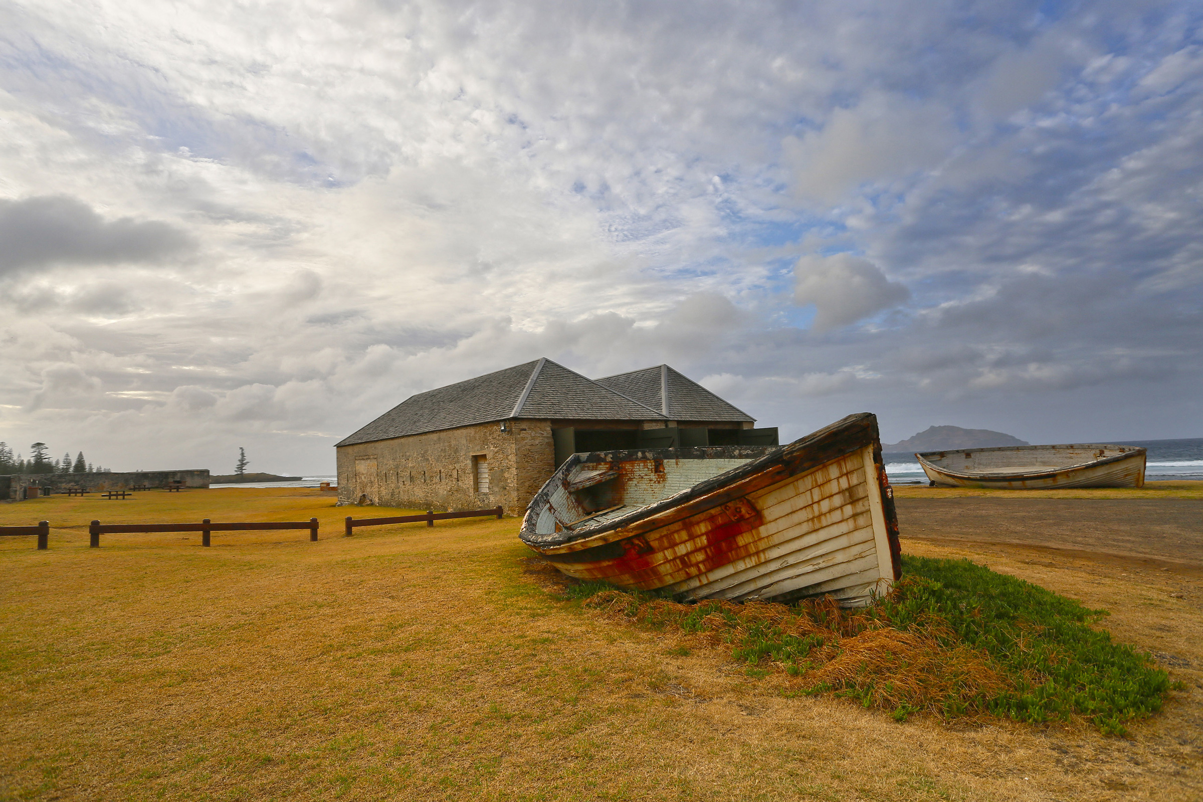
The provincial capital and administrative centre is Kingston, on the south side of Norfolk Island, in a picture-postcard setting on the shore of Slaughter Bay. Government House, the official residence of the Administrator, stands on Quality Row in the UNESCO World Heritage Site of the former penal settlement. The island’s major settlement and commercial hub is Burnt Pine, about 3km inland near the airport.
Norfolk Island has a resident population of about 1800 people, of whom nearly half are descendants of the Bounty mutineers who migrated here from Pitcairn Island in the 1850s. The islanders speak both English and a creole language known as ‘Norfuk’, a blend of 18th century English and Tahitian. In 2004, an act of the Norfolk Island Assembly made Norfuk a co-official language of the island and efforts are being made to keep it alive via dictionaries and the renaming of some tourist attractions.
ISLAND LANDSCAPES
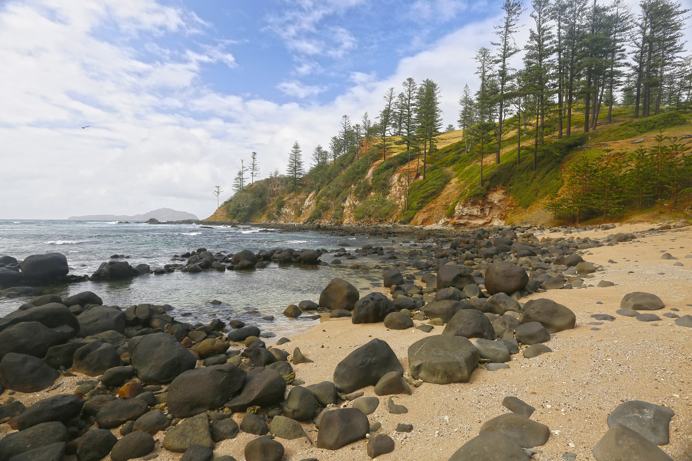
The islands are the exposed pinnacles of the Norfolk Ridge, a narrow, steep-sided range of seamounts running 1600km from the northern tip of New Zealand to New Caledonia. Norfolk Island has an area of 35sqkm dominated by two peaks, Mt Bates and Mt Pitt (both about 320m), the eroded remnants of volcanos that were active about 3 million years ago. The hinterland of hills and fertile red-soil plains slope generally south towards Slaughter Bay and Emily Bay near Kingston, and are mostly devoted to farming and agricultural activities. Norfolk is bound by a rugged coastline of cliffs that drop sheer to the ocean, while the southern bays are protected by fringing reefs populated by coral and colourful fish.
Phillip Island lies 7km to the south of Norfolk. Its geological fabric is a complex of fossil-bearing limestone, compacted volcanic ash (tuff), and basalt lava, fringed by rock platforms and a boulder-strewn coastal margin. The interior landscape has been extensively stripped of vegetation by feral rabbits introduced by European settlers, exposing a deeply dissected terrain of dyke ridges and gullies in a striking palette of rich reds, purples and yellows. Following the eradication of the rabbits in 1986, the island’s degraded environment is gradually being rehabilitated with native plants and birdlife.
THE NATURAL ENVIRONMENT
The Norfolk islands enjoy a mild, subtropical climate, with average temperatures in a seasonal range of 10–28 degrees. Annual rainfall is around 1300mm, mainly between April and August. Summer winds are south to south-easterly, and winter winds west to south-westerly.
The Territory’s natural habitats are a blend of tropical and temperate oceanic environments, colonized by plants and animals that arrived by chance dispersal over vast distances of ocean. Having evolved in relative isolation, many species are unique to the islands, like the Norfolk parakeet and the smooth tree-fern (the tallest tree-fern in the world). The islands are home to 182 native plant species, of which 51 are endemic and 15 are considered critically endangered. Birds account for the largest number of animals, with 116 species, including 15 endemic residents and many migratory seabirds that come to breed and forage in the coastal waters.
Before European settlement, subtropical rainforest covered most of Norfolk Island, with a canopy of native pines and an understorey thick with lianas and ferns. Only one small tract of rainforest remains, conserved in the Norfolk Island National Park which covers 6.5sqkm across the islands.
THE MARINE ENVIRONMENT
The Territory is surrounded by a 200nm (370km) Exclusive Economic Zone (EEZ) controlled by the Australian Government. Within the EEZ, the Norfolk Marine Park spans 188,444sqkm from the islands’ high-water line to a seafloor depth of 5000m.
After separating from the East Australian Current offshore from New South Wales, the Tasman Front crosses the Norfolk Basin at around 31°S before encountering the Norfolk Ridge. Here, the two interact to concentrate nutrients and plankton in productivity hotspots over the ridge, attracting mobile species such as turtles, cetaceans, tuna and billfish. The currents also transport species from the west, to enhance the richness and diversity of marine life over the ridge.
The result of these ecological processes is a mixture of tropical and temperate species that include 32 kinds of coral, 546 macro-invertebrates and 254 fishes, 61 of which are protected under Australian law as being vulnerable or endangered. As well, Norfolk’s islands and seamounts act as oceanic stepping stones for the dispersal of deep-water species and waypoints for migratory whales, dolphins and whale sharks.
NORFOLK ISLAND INSHORE FISHERY
The marine park immediately surrounding Norfolk Island is a Special Purpose Zone, within which the Norfolk Island Inshore Fishery (NIIF) has been created. The NIIF, known locally as ‘the Box’, encloses an area 67 by 40 nautical miles, incorporating shelf waters with an average depth of 40m. An agreement with the Commonwealth through the Australian Fisheries Management Authority (AFMA) permits fishing within the Box for recreational and charter-based purposes. No commercial permits currently exist for this fishery.
All fish are caught by line only, either from the shore or from boats lowered to the water by crane at Kingston or Cascade Bay piers, on opposite sides of the island. Prevailing winds and sea conditions dictate which jetty is used. For land-based anglers, the two piers provide a stable and generally safe platform, while Ball Bay and Bumboras offer access to large sections of walkable shoreline suitable for lure fishing or launching a kayak.
Boat-based fishing typically occurs further than 5nm from shore in depths of 20–25m around reef pinnacles north-east and south-west of the island. The Norfolk Island Fishing Association advocates a voluntary limit of 3 hooks per line to preserve the sustainability of the fishery, although more hooks may be used in deep waters (greater than 75m) to compensate for the time taken to wind up lines from these depths.
Trumpeter (Redthroat Emperor) is the predominant catch, followed by Yellowtail Kingfish and Ophie (Silver Trevally). Other important fish species encountered in the waters around Norfolk Island include Coral Rockcod, Queensland Grouper, Salmon, Snapper and Yellowfin Tuna. Sharks (Tigers, Whites, Hammerheads and Bronze Whalers) are also seen quite often when fishing from boats.
Further offshore, a limited number of line operators target commercial species in the Eastern Tuna and Billfish Fishery outside the NIIF to the limit of the EEZ around Norfolk Island.
POLYNESIAN SETTLEMENT
Sometime during the 13th century, Norfolk Island was settled by Polynesian seafarers, either from the Kermadec Islands or from the North Island of New Zealand. Their main village site was at Emily Bay, where structural remains and stone tools have been found. Melanesian artefacts have also been located, suggesting that people from New Caledonia may have reached Norfolk as well. For reasons that are unclear, these early settlers departed, and the island was uninhabited for a few hundred years before Europeans arrived.
ENTER JAMES COOK
James Cook rediscovered Norfolk Island on 10 October 1774, on his second voyage to the South Pacific aboard HMS Resolution. He claimed it for the British Crown and named it in honour of Mary Howard, Duchess of Norfolk. When Cook came ashore, he found the island uninhabited but growing abundantly with giant pines, which he thought would be suitable for ships’ masts, and flax plants for making sail cloth and cordage. He took samples of both back to England, but the products were later proven to be unsuitable.
A GARDEN FOR THE NEW COLONY
Norfolk remained uninhabited for another 14 years until 6 March 1788, when Lieutenant Philip Gidley King arrived on a mission for Governor Arthur Phillip to establish a farming settlement for the production of food to augment supplies in the fledgling colony at Port Jackson. This he did with a party of 7 free men and 15 convicts, and the enterprise flourished. (The anniversary of King’s arrival is commemorated by the residents of Norfolk Island on Foundation Day.)
By February 1790, food in the mainland colony was once again in short supply and the settlers were on the brink of starvation. To avert disaster, Phillip sent HMS Sirius and HMS Supply to Norfolk Island with 400 convicts to boost manpower for farming there and to relieve pressure on the government supplies at Sydney Cove.
On 19 March, the ships were anchored in Slaughter Bay, opposite the main settlement at Kingston, when a sudden storm trapped them against a rocky lee shore. Supply managed to work safely out to sea, but Sirius was thrown back onto the reef and wrecked. The archaeological remains of Sirius in Slaughter Bay are protected by legislation and inscribed on the National Heritage List in 2011.
Despite its initial success, the settlement struggled in later years with crop failures and difficulties with transport and communication because of remoteness and lack of adequate harbour facilities. The island’s inhabitants were gradually repatriated to the mainland and, by 1814, the settlement was abandoned.
THE PENAL DARK AGE
Norfolk Island was re-occupied in 1825 by the establishment of a penal settlement to incarcerate capital crime ‘lifers’ and convicts deemed by the colonial authorities to be hardcore recidivists. These were dark days for the island, both in terms of human suffering and the decimation of Norfolk's natural environment through large-scale agriculture and expansive building works. But this grim chapter in the island’s history came to an end in 1855 when the convicts were removed, and the settlement abandoned once again.
THE PITCAIRNER REVIVAL
Following their seizure of HMS Bounty on 28 April 1789, the mutineers, led by Fletcher Christian, spent many months searching the South Pacific for a safe haven to escape retribution by English authorities. In January 1790, they (and their families created with islanders along the way) settled on Pitcairn Island, but within 60 years the island had become too small to sustain their growing population.
On 8 June 1856, after successfully petitioning Queen Victoria for the right to occupy the now vacant Norfolk Island, 194 Pitcairners arrived to establish a third, permanent settlement. Although some families subsequently returned to Pitcairn, Norfolk’s population continued to grow, and today their descendants account for nearly half the resident population. The anniversary of the Pitcairners’ arrival on Norfolk Island is celebrated with a public holiday on Bounty Day.
RECREATION
Norfolk Island’s fascinating history is laid out in several excellent museums housed in well-preserved buildings along Quality Row and the park-like UNESCO World Heritage Site at Kingston. The island also offers boundless opportunities for outdoor recreation in magnificent natural environments, both on land and on the water.
The national park and botanic gardens can be explored on almost 10km of scenic tracks, ranging from serene ambles through lush rainforests to invigorating climbs to mountain peaks and meanderings along cliff tops with breathtaking coastal vistas. Twitchers will encounter abundant birdlife in the towering pine forests and cliff-side rookeries, especially during the summer breeding season when flocks leave the nests for aerobatic displays over strategically placed lookouts. A 20-minute boat ride connects Norfolk with Phillip Island for a day of trekking over its unique and colourful landscape and fishing off the rocky shores.
Norfolk is blessed with several golden beaches lapped by the clearest aquamarine water in the South Pacific. Sheltered Emily Bay is ideal for swimming and snorkelling, the beautiful coral reef in Slaughter Bay may be viewed in a glass-bottom boat, and dive tours explore the Sirius wreck site. For those looking for a bit more action, experienced surfers will find good waves at Anson and Ball Bays and Bumboras.
NORFOLK MARITIME
There are no ports or harbours (as such) in the Norfolk Island Territory. All goods brought in by ship are delivered to either Kingston or Cascade Bay, but vessels can’t get close enough to the piers to unload directly onto them. Rather, the cargoes are offloaded five tonnes at a time into whaleboats, which are then towed by launch to the pier where a mobile crane hoists the freight onto the jetty using nets and straps.
It is not wise to approach, or depart, Norfolk at night as there are some semi-submerged rocks around the island and no lead lights or markers to assist navigation. It is far better to wait until daylight and work a safer, deep-water passage to an anchorage.
There are a number of anchorages around the island, but none are considered safe in all weather conditions. Therefore, a boat should never be left unattended, and crew should only go ashore in settled weather. Be prepared to seek alternative anchorages as dictated by changes in weather conditions.
Around the island, anchorages may be found at: Sydney Bay off Kingston, in depths of 8m if winds are from the NW-NE quadrant; Anson Bay, in fresh E winds, off the beach in 10m over a sandy bottom; Cascade Bay off the wharf, in SW winds; and Ball Bay on the southeast side of the island, in winds from the W quadrant.
CLEARANCE FORMALITIES
Kingston is the official Port of Entry for the Territory of Norfolk Islands and is treated as an Australian port for border control purposes. Although voyages between Norfolk Island and mainland Australia are deemed domestic travel if completed within 30 days of departure, immigration, customs and biosecurity clearances are required on arrival at each end. These are carried out by the Australian Border Force (ABF).
Notice of impending arrival in Norfolk Island must be given to ABF up to 12 hours in advance. This can be done by email, fax or phone. As soon as practicable after arriving, the captain or master should contact the ABF Norfolk Island office on VHF Channel 16 (business hours only) to arrange a time and location for clearance formalities. Prevailing weather and sea conditions will dictate where and when this can occur, at either Kingston or Cascade Bay.
Passports and visas are not required when travelling to Norfolk Island from the Australian mainland. However, photographic identification must be produced for each passenger (including children) and a valid passport is the preferred documentation to expedite processing.
The usual biosecurity restrictions apply to all vessels entering Norfolk Island. All food, plant material and animal products must be declared and inspected on arrival, and may require treatment or documentation prior to entry. Biosecurity risk goods may be quarantined, seized or destroyed. No fruit, vegetables or food of any kind is to be taken ashore.
If you intend to bring cats or dogs into Norfolk Island from mainland Australia, notice must be given at least three days before arrival and you must comply with Norfolk Island Regional Council animal importation requirements and conditions set by the Department of Agriculture, Water and the Environment to manage biosecurity risks.
Clearance out by ABF is also required before departure and advance notice should be given to avoid delay. For vessels intending to travel to the mainland, clearances will only be given to proceed directly to another Australian Port of Entry where a further clearance will be undertaken on arrival.
CONTACTS
NORFOLK ISLAND TOURISM
W: norfolkisland.com.au
NORFOLK ISLAND REGIONAL COUNCIL
9 New Cascade Road, Norfolk Island
P: +6723 22244
E: customercare@nirc.gov.nf
W: norfolkisland.gov.nf
AUSTRALIAN BORDER FORCE
Norfolk Island - District Office
67A Taylors Rd, Burnt Pine
P: (02) 6246 1325
M: +672 351 881 (after hours)
F: (02) 6275 5078.
E: norfolkislandabf@abf.gov.au (general)
E: yachtreport@homeaffairs.gov.au (yacht report)
VHF Channel 16 (business hours only)
DEPARTMENT OF AGRICULTURE & WATER RESOURCES
World Traders Complex, Taylors Road, Burnt Pine
P: 1300 004 605
M: +672 3 22 441 (business hours)
M: +61 438 440 950 (after hours)
W: agriculture.gov.au/biosecurity/avm/vessels